My thirteenth multi-day hike, with appropriate luck unfortunately. Broke a hiking pole, torrential rain, dodgy river crossings, thunder, lightning and hail, iPod stopped working in one ear, and hurt myself in all the wrong places for hiking (knee, wrist and palm) before I even started the track. Thankfully it was balanced out with some good luck. The weather cleared while crossing the near 1,800m Travers Saddle, saw rare blue ducks, sun came out over Lake Angelus and along Robert Ridge, and had a thirty bunk hut to myself, literally six hours away from another human being, most alone I’ve been in my life.


Spent five days walking 78km around Nelson Lakes on the Travers-Sabine Circuit via Angelus Hut, with a side trip out to Blue Lake and back. A few days before I’d removed most of the skin from my right knee and left wrist through excessive speed and poor station design, while running to catch a train. My flight to Nelson was delayed by an hour, and the forecast was for heavy rain for the next two days…
It was overcast but dry by St Arnaud’s famous jetty on Lake Rotoiti, under which enormous eels waited.


Made up for lost time from the delayed flight by taking a water taxi over to Lakehead Hut, skipping 10km of bush. Still had 21km of that to come before reaching my home for the night.

Took me couple of hours to adjust to being on the track. Quite surreal going from my bed at home in the morning to by lunchtime walking along long yellow grass filled valleys surrounded by mountains.

Travers Swingbridge was one of the dodgiest I’ve been on, involving a lot of scary wobbling to make it over to the other side.

There were some inviting detours off the track but perhaps fortunately I didn’t have time.

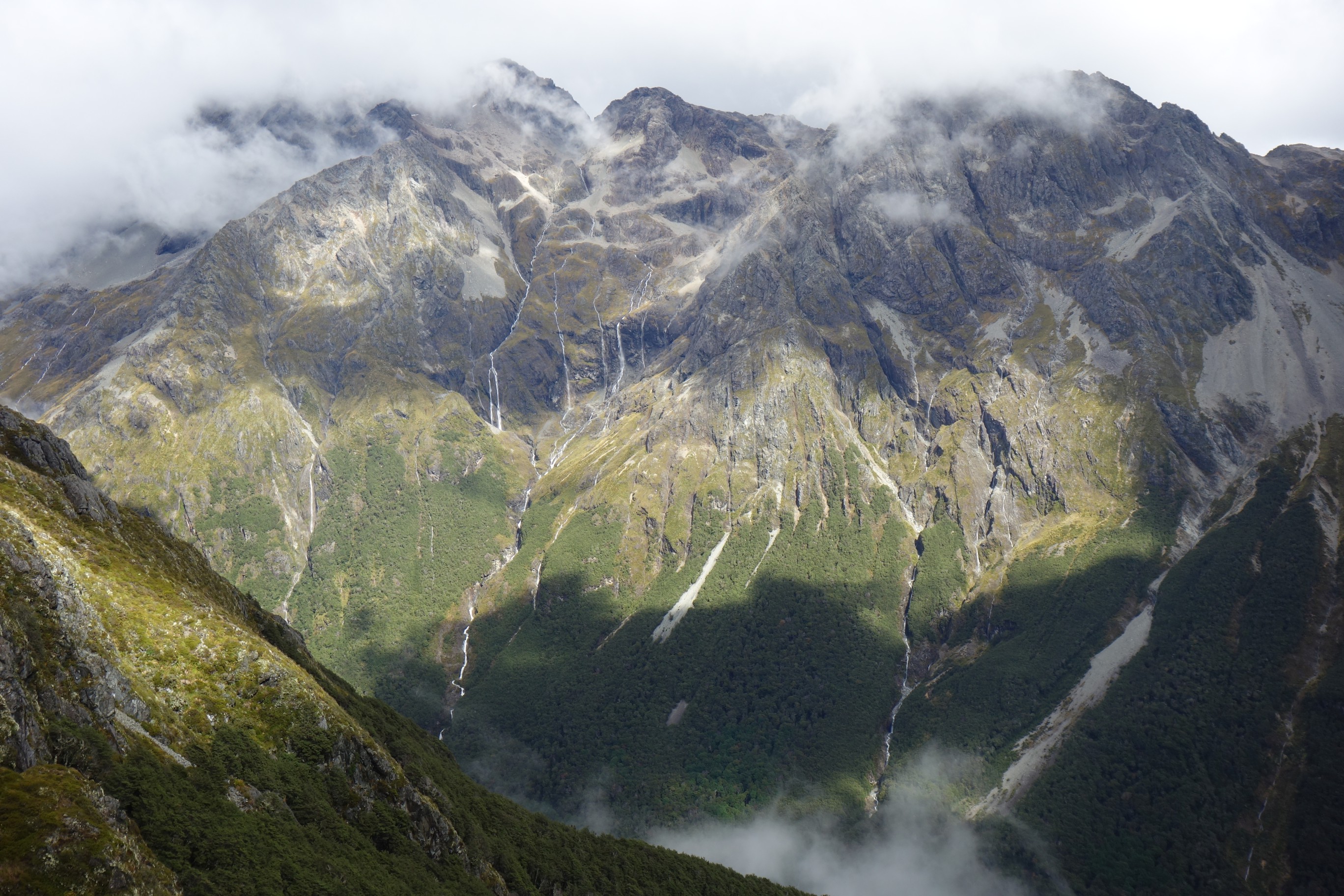
After three and half hours I reached the empty John Tait Hut. I was pretty wet by that point but soon after reached complete saturation, with a tough three hours left to Upper Travers Hut.

There were some impressive waterfalls to distract but it was a great relief to finally see the hut in the distance.


Got there by 6.45pm to find it deserted. Unexpected (first time for me) and pretty erie as darkness closed in (with only my torch to keep it at bay) and the rain got heavier. I was literally at least six hours walk from the nearest other person, most alone I’ve been in my entire life, quite a thought.

Heavy rain continued all night. It sounded like there was a river running right by the hut. Discovered in this morning that this was actually the case, with the paths now streams.

My legs felt like they’d been in a fight. And lost. Perfect preparation for what was going to be a far tougher day than yesterday, ascending 450m up over the near 1,800m Travers Saddle and descending steeply 1,100m down to West Sabine Hut, with a further 8km onto Blue Lake Hut. Given the continued rain I was tempted to wait it out in the hut, particularly after reading the sobering notice below, but the forecast was for the rain to lift so I got going up the saddle.


And I’m glad I did as after an hour a half I reached the highest point, the skies cleared and I was rewarded with some quite spectacular views.


After a steep descent down into the valley all was going well, until I came across this…


Which didn’t look very passable to me… Had a good look up and down for an easier place to cross but simply too much water coming off the mountains after the heavy rainfall. Put my theoretical knowledge to practice, and did what I’m not very good at. I waited. For two hours. Filled my time with lunch and The Economist on my iPhone.
Finally it looked at little more passable and twenty seconds and some very wet boots later I was across.
Put the time pressure on though. Got to West Sabine Hut by 5pm and I was tempted to stay but even more keen to make it to Blue Lake. I had a couple of hours of daylight left, which wasn’t quite enough. Made it to Blue Lake Hut in darkness by 8pm and promptly collapsed on a bunk and started to shiver from exhaustion.


Thankfully felt better in the morning, despite being woken by what sounded like a small jet engine, which turned out to be a turbo gas cooker. Had time to see Blue Lake, home to some of the clearest freshwater in the world.

Along with a pair of rare blue ducks, quite happy just a few feet away from me, most unusual for wildlife unless you’re in the Galapagos.
Just about worth the tough five hour and 16km detour from West Sabine Hut. In retrospect it was a bad call but I decided not to have an early lunch at West Sabine (was only 10.30am), and instead continued onto Sabine Hut, 15.5km and five hours away. Learnt the hard way that attempting 23km in one go without more than a couple of minutes break for water or a muesli bar wasn’t a great idea.
Early on I slipped on a rock, with my hiking pole taking the damage. It gained a slight bend, which got worse as I continued, until it basically feel apart. Which is how I felt as I got slower toward the never appearing hut, my legs fine (other than about 30 sandfly bites!), but my hips and shoulders suffering from the weight of the pack. It was such a relief to finally find the hut on the idyllic shores of Lake Rotoroa, approached in daylight for once.


The penultimate day from Sabine Hut to Angelus Hut via Mt Cedric was only 6.8km, but the hardest 6.8km of the trip, climbing over 1,200m. It was tough from the start with a super steep ascent through the bush, literally using tree trucks to pull myself up the slopes, trying to avoid slipping on the mud and leaves.


I hoped the ascent would end with the tree line, but it continued on up the hillside, though I was rewarded with some fleeting glimpses behind me of Lake Rotoroa between passing clouds.


I reached the ridge line which reminded me of diving, with rocks looming out of the cloud, though flashes of sunshine lit up the mountainside.


About four and a half hours in I reached the most treacherous spot to date. Took half an hour, but felt longer, to navigate the endless piles of slippery even when dry rocks. Which then got wet toward the end as it started to rain.

Finally by 2pm I reached the hut, getting pretty wet in the process.

After ten minutes it cleared though with perfect reflections on Lake Angelus in front of the hut.


I was one of the first to arrive which I became increasingly grateful for as the weather deteriorated again to heavy hail, thunder and lighting by half three. Pretty much everyone arrived into the hut after this completely soaked.


One unexpected bonus was the overflowing gutter formed a pile of snow, which we turned into a snowman.

The sun came out illuminating this quite beautiful spot.


Curiosity later took me up the hillside, past the smart toilet block, with views back toward the hut, down the valley with last rays of the setting sun. Nice way to end the day.


By the morning the valley was filled with low lying cloud and the rising sun hit the lake basin.


I had planned to take a side trip up to the summit of Mt Angelus but general tiredness, and the state of my knee, changed my mind.

Set off along Robert Ridge, mostly clear to the right of me with stunning views, and mostly cloudy to the left of me bringing some strong winds.


After three hours I reached the top of the switch back down to Mt Robert car park, with impressive views out over Lake Rotoiti, St Arnaud on it’s banks, and valleys and farmland around.

Returned to civilisation, showers, fresh fruit and vegetables and lots of emails, so I escaped again back down to the lake a couple of times.


Leave a Reply