My first and favourite Great Walk, the Routeburn Track is a 32km, 2-4 day walk through some of the finest scenery in New Zealand, and therefore probably the world. It has pretty much everything – snow capped mountains, huge waterfalls, beautiful lakes, thick forests and epic valleys. These photos were taken over Christmas, I’ve also walked much of it in June if you’re interested in a wintry contrast.

IMG_2195

Started from the Routeburn Shelter, half an hour from Glenorchy on a perfect December day, blue skies but cool, and endless daylight. Had 20km to go to Lake Mackenzie Hut, 1,000m uphill and 500m downhill.

Headed through the bush, across bridges spanning bubbling streams, to Routeburn Flats where the sand flies encouraged me to move swiftly onto tackling the ascent to Routeburn Falls.

IMG_2077

The effort was rewarded with classic Routeburn views while eating my lunch from the comfort of the hut balcony.

IMG_2151 IMG_2162

I would have been happy staying there for the rest of the day, and most people do, but it was only midday so I pushed on past rainbow enhanced waterfalls just above the hut.

IMG_2174 IMG_2175

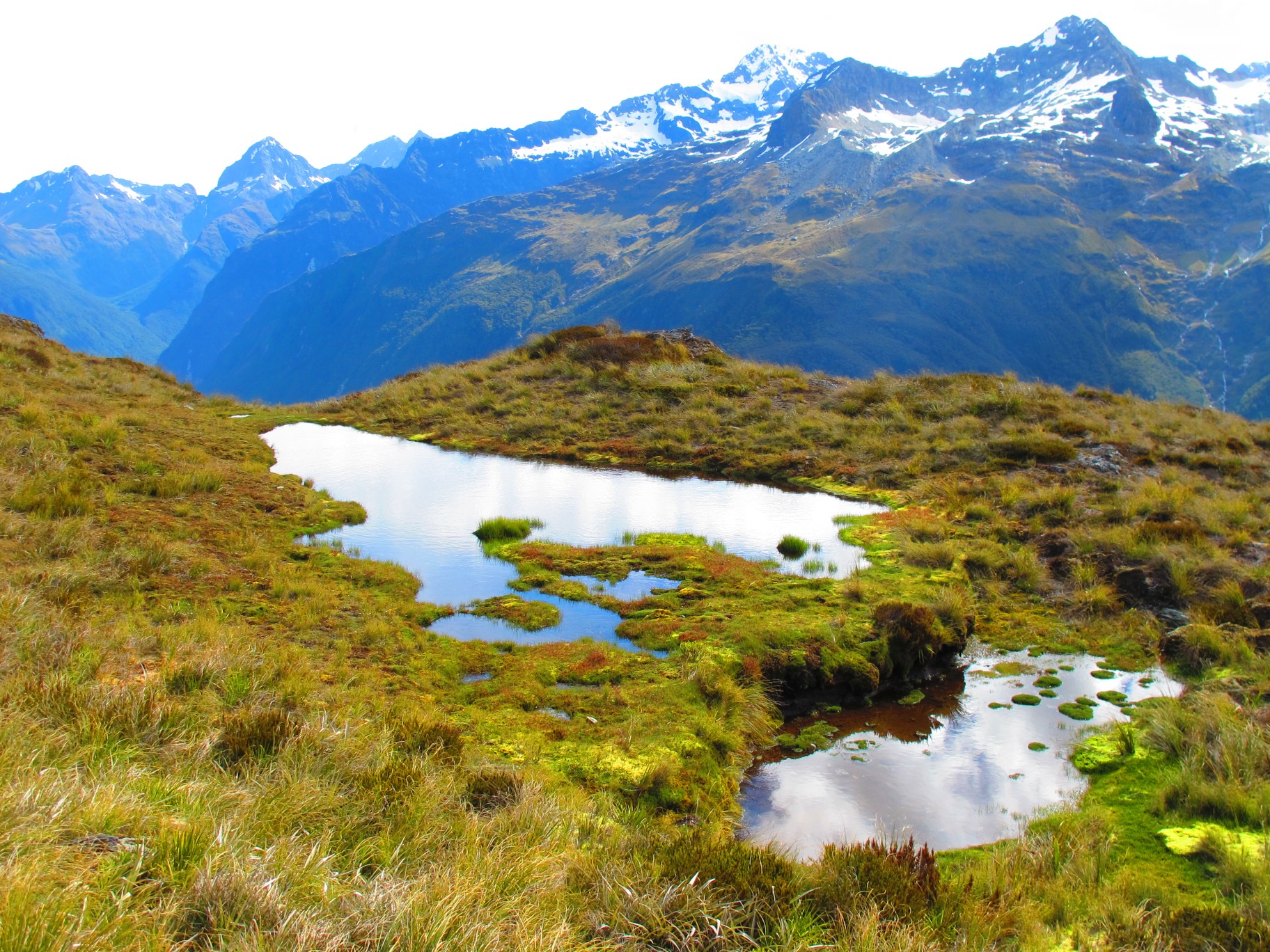
The next section over the Harris Saddle was the best part of an already spectacular walk, past the majestic Harris Lake.

IMG_2243 IMG_2285

IMG_2408

I left my pack at the shelter to head up Conical Hill to gain more height and corresponding views.

IMG_2291 IMG_2295 IMG_2298 IMG_2301 IMG_2307

IMG_2338

Crossing the Harris Saddle I was greeted by the the jaw dropping sight of Lake Mackenzie at the bottom of the valley, and my home for the night, Lake Mackenzie Hut, on the edge of the crystal clear (if freezing cold) lake.

IMG_2470 IMG_2460 IMG_2456 IMG_2513

A forty minute return warm up walk in the morning took me to the unusual Split Rock, before continuing along the track by the 174m Earland Falls.

IMG_2539 IMG_2543 IMG_2550 IMG_2608

I just about had the energy for one final push for a side trip up Key Summit for beautiful alpine vegetation and mountain views before finishing at the Divide, an hour and a half from Te Anau, lined up for my next adventure on the Kepler Track.

IMG_2635 IMG_2640 IMG_2650

Highlights: Views toward Humboldt Mountains and valley heading up to Routeburn Falls Hut, walking around Lake Harris, along Hollyford Face looking toward Darran Mountains, descent to Lake Mackenzie
Lowlights: Few sand flies at Lake Mackenzie, carrying all my non-tramping gear as I went from Queenstown to Te Anau – 20kg pack not recommended!
Route taken: One night, started at Routeburn Shelter (bus from Queenstown via Glenorchy), stayed at Lake Mackenzie Hut, finished at the Divide (bus onto Te Anau) – doable but long first day (20km plus up Conical Hill)
Tips: Leave your pack at the shelter before going up Conical Hill, don’t carry too much water as you can fill up from the fast flowing streams between Routeburn Falls and Lake Mackenzie Huts, take the 40 min side trip from Lake Mackenzie Hut to Split Rock before heading on

23 responses to “Routeburn Track”

  1. I wanna cry out of jealous. This place is amazing! You captured it very well. I love it! 🙂

  2. […] Routeburn Track (32km, 2-4 […]

  3. […] Routeburn Track 2. Tongariro Round the Mountain 3. Travers-Sabine Circuit, Angelus Hut and Blue Lake detour 4. […]

  4. […] of the South Island, with the majority of the track in Fjordland National Park (also home to the Routeburn, Milford and Kepler Tracks further […]

  5. […] Mackenzie Hut, Routeburn Track The first hut I ever stayed in. Beautifully located on the shore of Lake Mackenzie, and probably […]

  6. […] took a while to put it together, didn’t realise Auckland had so many community theatres!6. Routeburn Track Appropriately my favourite track is also my most popular track […]

  7. […] Routeburn Track is deservedly one of the most popular walks in New Zealand. The Sugarloaf / Rockburn Track starts […]

  8. Absolutely amazing photos 🙂 Wowwww.
    Does it make a difference if you start at the Routeburn Shelter vs the Divide? In terms of logistics (like where you park your car and easy shuttle bus access to the trailhead), scenery, and difficulty (trail elevation)?
    Thank you! I can’t tell you how helpful your blog is!!! And how lucky you are to live in New Zealand!!!!

    1. Thanks Christine, appreciated. I think I made a good decision moving here 😉 In terms of your questions…

      Logistics – there’s plenty of shuttle buses, I got one from Queenstown to the Routeburn Shelter, and then a bus back from The Divide to Te Anau, and then back to Queenstown. If you’ve got a car you could leave it at either end and there is a car relocation service, or use shuttle buses. In terms of security though you’re best to leave it in a town and get a shuttle bus to the track ends.

      Scenery – it’s spectacular either way, just take a look over your shoulder at times to see what is behind.

      Difficulty – it’s pretty similar, you’ve got to go up then down either way, though probably a little gentler coming from The Divide end.

      1. I’m really jealous and I live in Hawaii, which is not exactly a flop place haha :-).

        Thanks so much for all the helpful information! Glad to hear there are plenty of shuttle buses; I think we’ll probably be relying on that as we want to save on our car rental so we might just return the car when we get to Queenstown before doing the hike. I’m a huge LOTR nerd too so I’m dying thinking about all the things I’ll recognize from the movies! Seems like a lot of it was filmed on the South Island! YAY!!!

        You’re awesome, thank you again! Sorry I have so many questions!

  9. […] Routeburn Track was my first proper tramp (New Zealand hike), an 37km overnight adventure over Christmas 2013 which […]

  10. […] 20 minutes drive from the start of the Routeburn Track, Kinloch is a blissful spot at the top of Lake Wakatipu. There’s nothing there other the […]

  11. […] users). It was followed by Patagonia, Argentina & Chile v South Island, New Zealand, and the Routeburn Track rounded out the top three, all with a tramping / hiking […]

  12. […] The Routeburn Track in Fiordland is one of New Zealand’s Great Walks. It’s 37km and 3 days worth, or 2 longish ones in my case with the weather closing in (of course some over-achievers run it in an afternoon). The range of scenery – mountains, waterfalls, beech and fern forests, epic glacial valleys and tarns, ending beside Lake Wakatipu in hobbit country – is a bit special. See for example pics at https://jontynz.com/2016/04/09/routeburn-track/ […]

  13. […] Routeburn Track, December 2013 and June 2017 (as day walk) My first tramp, with great weather, which got me hooked. […]

  14. […] to relax for a few days, or use as a base before doing some of the walks in the area such as the Routeburn or Hollyford […]

  15. Want to do this one next!!

    1. It is wonderful, though will be significantly busier than the Aotea Track. As a Great Walk the huts book up months in advance. It can be done in one long day but missing the two side trips which are highlights of the track

  16. […] Routeburn Track was my first proper tramp (New Zealand hike), an 37km overnight adventure over Christmas 2013 which […]

  17. […] a shuttle bu, so lacked the time, and to be honest the energy (did Kepler back to back with the Routeburn Track), to tackle the super steep track back up to the ridge for views. Just means that I’ll do the […]

  18. […] Routeburn Track, December 2013 and June 2017 (as day walk) My first tramp, with great weather, which got me hooked. […]

  19. […] Routeburn Track, December 2013 and June 2017 (as day walk)My first tramp, with great weather, which got me hooked. […]

Leave a Reply to Most popular posts of 2017 | jontynzCancel reply

LATEST POSTS

Discover more from Jonty travels...

Subscribe now to keep reading and get access to the full archive.

Continue reading