The Snowman Trek has a reputation as one of the longest and hardest hikes in the Himalayas. It takes around 24-28 days to walk ~350km, crossing eleven passes over 4,500m, with the highest at 5,345m. It is said that more people have climbed Everest than have completed the full Luana Snowman Trek. I walked it in September / October 2019 with The Mountain Company. Here’s what I learnt…
About 50 people a year walk the full Luana Snowman, between Shana and Minchugang. By comparison over 800 people a year summit Everest. The numbers are probably a reflection of the limited number of people keen to spend a month sleeping in a tent, generally at over 4,000m above sea level, with only a couple of basic showers, and walk 4-8 hours a day during all weather conditions, through often thick mud, with very few flat or easy sections.
The main reason I suspect though is the cost, as the Snowman is twice the price of comparable hikes in Nepal. Everyday spent in Bhutan costs USD250 during the hiking season, though this includes accommodation, transport, food, a guide, and USD85 for the government. Add onto this a Western guide and company margin and you’re looking at between USD7,500 and USD9,000 to walk the Snowman, including a few days either side of the hike for acclimatisation and travel back to the airport at Paro.
It isn’t possible to walk anywhere in Bhutan without a guide. All tourists need to be accompanied by a guide while in the country, good for local knowledge and supporting the local economy, but I did miss the freedom of walking independently. The logistics of the Snowman are very challenging though, with weeks between resupply points, so even if a guide wasn’t required you’d still need a support crew and horses / yaks.

The vast majority of people walk the Snowman in autumn (late September / October) when the weather is relatively better, if still highly variable. In spring the rhododendrons and flowers along the track are in bloom, but there is even more rain to contend with.
Typically 6-8 groups walk the Snowman in autumn, including The Mountain Company, World Expeditions, and private trips, though many don’t do the full Luana section (the most scenic if toughest part) and instead take a shorter route back from Thanza. Most walk the track from west to east, which is logistically easier, allows more time for acclimatisation, and leaves the hardest days to the end, but there are usually a couple of groups walking west to east.
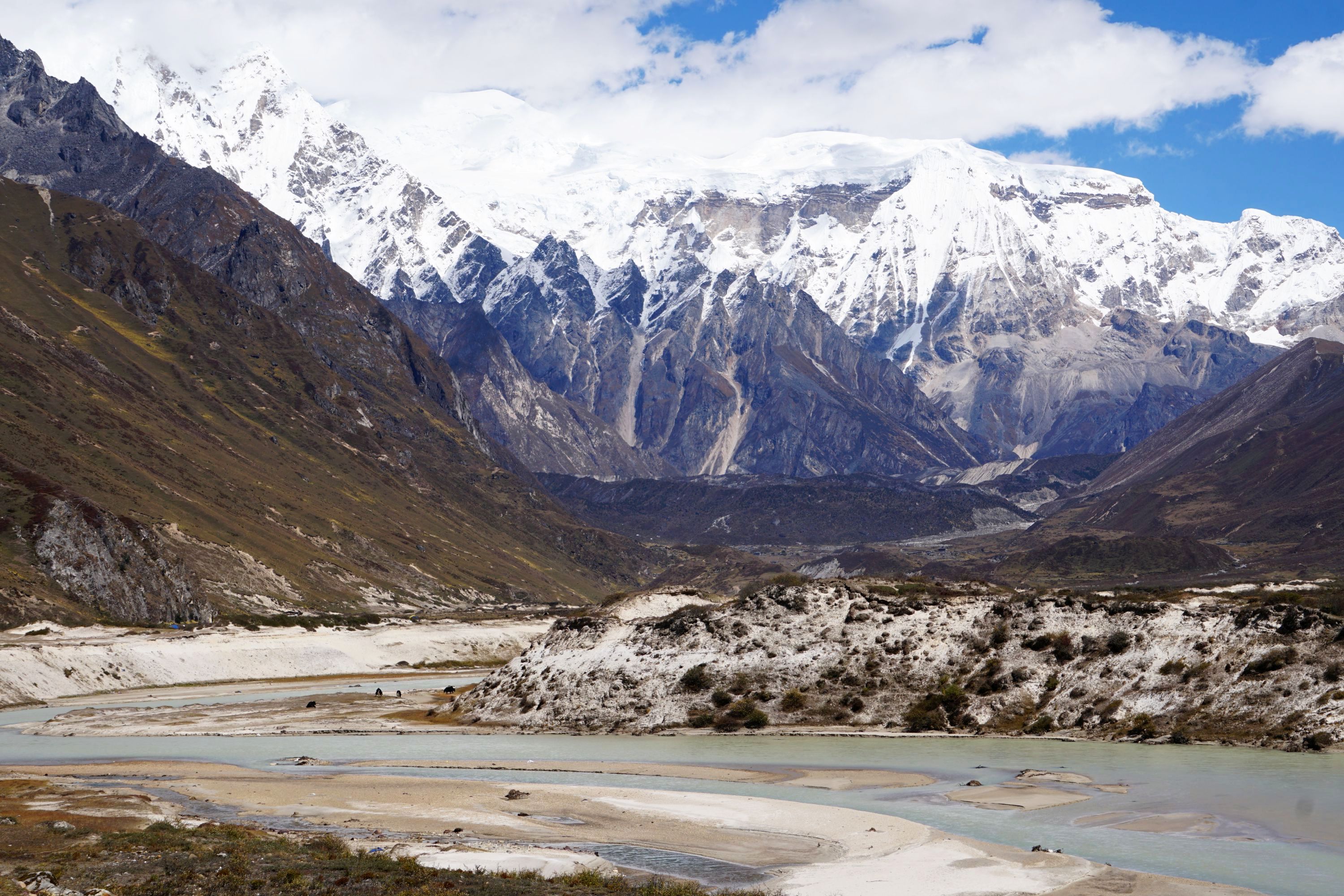
The main challenge with the Snowman is that the hiking season in Bhutan is one of the shortest in the Himalayas, and the trek takes the best part of a month. Start too late and the passes will be impassable with snow, start too early and most of the walk will be in monsoon rain. Starting in late September we had nearly two weeks of apparently typical weather for the tail end of the monsoon, with low cloud obscuring most of the views, and steady rain arriving mid afternoon and lasting through the night. Thankfully we made it to camp before the rain arrived almost every day, and only had a few hours walking in the rain.


About half way through the trip the weather improved considerably, with dry and sunny days, making for a much more scenic and enjoyable experience. This didn’t last though with rain and snow returning during the final week. One of the main challenges of the Snowman in comparison with hiking in Nepal and Ladakh (from what I’ve heard) is far less settled and predictable weather.


The first third of the Snowman is shared with the Jhomolhari Trek, and then the Laya-Gasa Trek. Almost everyone walks these tracks from west to east so it’s very uncommon to pass other hikers coming the other way. You may be sharing the track with a number of other groups but only cross them at the campsites, which have enough space that you don’t really see each other.

On the track you will see many more locals, particularly horse and yak herders, than other hikers. Almost everything in these regions is carried by horse mostly, or yak (mainly in the remote Luana region). We were typically passed by 3-5 groups a day until the final, most remote week. It is important to stay well away from any edges as they could easily knock you off the track by accident.


They do make a mess of the track and campsites though, with a constant need to watch where you step. I’m pretty sure that this is what made me ill half way through the trip as my pack, solar charger, and hiking poles may have picked things up from the ground.
The Snowman would be better called the Mudman as about two thirds of the track is thick mud. There are usually rocks to avoid the worse of the mud but it’s pretty thick and persistent in places, and worst during the final two days on the track.


There are lots of dogs around the camps on the earlier sections of track. They are lethargic during the day but come nightfall they run riot. It was rare to have a night without being woken at some point by them barking. Thankfully after Laya (about a third of the way through the trek) there are far fewer, though yaks can make some strange noises in the night…

There are very few easy sections, even the rare flat parts are generally across rocky riverbeds or muddy plains. The passes are apparently steeper than those in Nepal, though were nothing compared to ones I’ve crossed in Switzerland and New Zealand. Generally the track is easy to follow and isn’t particularly technical.

The challenges of the Snowman are both physical and mental. Walking everyday for a month at altitude, other than a couple of rest days, takes its toll on the body. I had a cuts on my fingers which took weeks to heal. I was ill half way through the walk, and it took 2-3 times longer to recover than if I’d been at home. Mentally the first couple of weeks were tough due to the weather and lack of views, half way things improved with significantly better weather and dramatic scenery, but the final week was a challenge both physically with some of the longest and hardest days, and mentally with the end so close and the novelty of camping wearing thin.
We walked the Snowman at the same time as a private group of two American couples. One of the couples (the ones who had persuaded the others to do the walk) left a third of the way through the Snowman as the husband had a chest infection. Continuing hiking at altitude would have made the situation worse.
We also lost three members of our group at the same time, due to concerns about altitude and the seemingly unrelenting poor (if seasonally typical) weather. Laya is the last opportunity to exit the track relatively easily, with a road end about four hours from the village. Like most hiking tracks in Bhutan roads are eating away at the start and end points, but for almost all of the Snowman you’re probably closer to the border with Tibet than to a road.

Another member of the group got an infected fingernail, causing his finger to swell to double the usual size and turn green…
Toward the end of the Snowman one of the crew became seriously ill, with significantly swelling in the lower half of his body. Due to the low cloud it wasn’t possible for a helicopter to land so he had to walk two long and painful days to the end of the track to get to a hospital.
Each time people left the group able crew had to accompany them so by the end we were down two guides, two kitchen / tent crew, and three guests. I could have easily been the fourth guest if I had stayed as ill as I was for another day or two. The Snowman lived up to it’s reputation as a tough walk…
There is plenty to photograph along the way, from >7,000m high mountains to remote Bhutanese villages to autumnal valleys. As a comparison though I took more photos in nine days hiking the Walker’s Haute Route in Switzerland as I did in a month walking the Snowman.


There are no bugs or dangerous animals to worry about, other than a few hornets to avoid on the way to the Duer hot springs. It’s too cold and high for mosquitoes, which made a welcome change from most hiking I’ve done. All the rivers were spanned with bridges or logs. The main risks are probably twisting your ankle slipping on muddy stones, fatigue from the duration and altitude of the walk, or getting ill given how remote the track is.
One quirk of many campsites along the Snowman is that they are not level. Sometimes you’d be escaping out of the tent feet first due to the slope, while other times you would feel permanently like you were going to roll off to the side. The most disconcerting camp though had a slight inverted U shape, where my stomach was higher than my head and feet, mitigated to some degree by propping up my head with layers.

At the same time as we walked the Snowman Trek the Snowman Calibration Run was held, a trial run for the hardest ultramarathon in the world. Participants cover 275km, from Laya to Bumthang, in five days. Walking this section in 14 days was hard enough, but the winner did it in 36 hours. The second day was the longest for participants, taking between 11 & 1/2 hours and 15 & 1/2 hours to cover 63km. There were seven entrants, all locals, who passed us between Danje and Tshorim. From next year it will be opened to internationals looking for a challenge!

This was the first time I’d travelled with The Mountain Company, who specialise in Himalayan hikes. I was impressed with their superb logistics and organisation, exceptional local crew, tasty and varied food, excellent tents and camp facilities, and well paced itinerary to ensure time for acclimatisation, though I also used Diamox throughout which helped with altitude.


A typical day on the Snowman Trek involved…
- Waking naturally with the sunrise between 5.30am and 6am
- Hot water / drinks brought to the tent at 6.30am
- Breakfast of porridge or cereal, and toast, eggs, sausages, and fruit from 7am
- Start walking at 8am
- Lunch of rice, meat, vegetables, and apple or orange slices, typically between 12 noon and 1pm. This is cooked in the morning and kept warm, and usually eaten on route as the crew needed time with the horses to pack up camp, overtake us on the track, and set up camp before we arrived
- Get to camp usually between 1.30pm and 3.30pm (though we were a fast paced group), with hot water provided to wash, and on two rest days a bucket shower was set up
- Afternoon tea of hot drinks and snacks at 3.30pm or 4pm
- Dinner of soup, and rice, meat, vegetables, sometimes pasta, and fruit or cake for dessert between 6pm and 6.30pm
- Group statistics taken after dinner, blood oxygen levels, pulse and Lake Louise score (measure of effects of altitude)
- Briefing on the next day
- Everyone disappears to tents by 7.30pm and no doubt sleep soon after
- Repeat 26 times… other than rest days where we started an hour later and had no walks planned
Some things I found most useful to take on the walk were…
- Solar charger, though it was often a challenge to get enough sunlight to keep everything going, given the often cloudy weather
- Thermal sleeping bag liner, adds additional warmth (important when sleeping at 5,200m above sea level!) and keeps your sleeping bag clean
- Kindle, as you will have plenty of free time at the end of afternoons, in the evenings, and on rest days to catch up with reading
- Diamox, used by perhaps a third of the group, suggest taking a quarter tablet in the morning and late afternoon, starting a couple a days before reaching altitude
- Z-Seat, extremely light foldable mat which is useful for sitting on during stops when walking, and putting under your hips below your inflatable mattress for extra insulation at night. The Mountain Company provided decent chairs at camp which were good for the back
- Umbrella, essential to keep the worst of the rain off while walking and wandering around camp
- Solar lantern, lightweight illumination for your tent
- Pee bottle, highly recommended, saves the need to leave your tent in the middle of the night, particularly when it’s snowing!


Leave a Reply