One of the best coastal walks in New Zealand, the Cape Brett Track is a technically easy but physically challenging hike near Russell in the Bay of Islands. It offers incredible scenery and interesting bush, though mid February may not be the best time to walk it unless hiking in high humidity and heat appeals.
Most people either walk the 16.3km track to the Cape Brett Hut and return the same way the following day, or take a 35 minute boat ride to be dropped off / picked up from the hut to save on repeating the track. Looking at the map I found an alternative return via the Te Toroa and Whangamumu Tracks, which added a few hours and more hills, but offered variety and the opportunity to visit the remains of the only land based whaling station in the world.
The Cape Brett Track starts at the pleasant Oke Bay, close to Rawhiti, a half hour drive from Russell. Even at the best of times water supply on the track can be an issue, and during one of the longest droughts on record there was no water at all. So I carried nine litres with me, bringing my pack weight to 20kg, not ideal given the hilly terrain…


Before the track officially starts, which requires a $40 permit to cross private land, there were some stunning views on the other side of the peninsula.

There were marker posts every km along the track, handy for understanding progress.

The track became more interesting, with a greater variety of trees and plants, and a few breaks in the bush offering views.


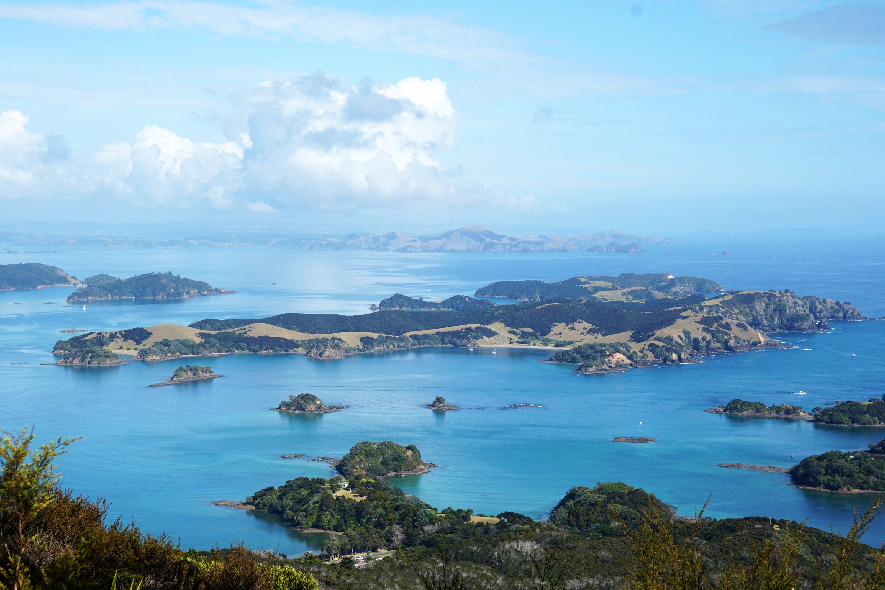
It was pretty much straight uphill to Pukehuia, the highest point of the track at 345m above sea level, with panoramic views of the Bay of Islands.

There were more views as the track follows the ridgeline.


There are some serious pest controls in place, including this electric fence and many trap lines along the track.


Almost exactly half way along the track is a conveniently located hut for DOC pest control workers. The bench outside in the shade was the perfect place for lunch.


Further along was the lovely Deep Water Cove, a detour off the track so I could leave my pack behind before venturing down and back up 110m.


The bush around here was enjoyable to walk through.


Though the main reason for walking the track was coastal views like this.


I was starting to flag a bit by this point, emerging out of the shade into the full force of New Zealand afternoon sunshine. This last section of track was the most spectacular though, with waves pounding against Cape Brett’s cliffs.


Off the coast of Cape Brett is Motukokako Island, famous for it’s ‘hole in rock’, a popular destination for boats in the Bay of Islands, though the hole isn’t visible from the cape itself.

The Cape Brett lighthouse was a photogenic addition to this landscape. Dating from 1910, it’s the last complete on site example in New Zealand. Inside is a giant clockwork mechanism, in use until 1978 when a replacement light was installed next to it.


Down from the lighthouse is Cape Brett Hut, the last remaining of three houses built in 1909, used by more than 100 keepers and their families over the years. There was even a school on site to teach the children of the keepers, but now just the foundations remain of most of the structures.

The hut requires booking online in advance, and costs $15. Another person was booked to stay in the hut the night I did (a Tuesday night, it is often fully booked at the weekends), but thankfully didn’t show up. After booking you get a code for the door to access the hut. Being there alone I was a little paranoid about locking myself out…


Down by the water is the landing / gantry, which used to be used for loading and unloading ships.


Near the hut was some of the most colourful grass I’ve seen.


After dinner I was joined by this seagull, which was a little too inquisitive. After leaving the back room open I found it inside the hut underneath my bunk!

The evening light was rather wonderful, though cloud blocked the sunset. After which the hut went from being enjoyable to a bit spooky in the darkness…


There was some colour in the sky in the morning at sunrise, and a lot of humidity. Everything I had with me was slightly damp to the touch, and despite the cloud I was drenched in sweat by the time I climbed back up the hill to the lighthouse.


Even without sunshine the landscape was still quite spectacular, and this second day was much quieter on the track. The previous day hadn’t exactly been busy, I met about 15 people, all bar one were day walkers, but as many were dropped off at Cape Brett or Deep Water Cove I came across them at unexpected parts of the track.


After three hours, and most of the way back along the Cape Brett Track, I branched off onto the Te Toroa Track. Judging by the comments in the Cape Brett Hut visitor book I suspect most people by this stage would welcome finishing soon. With my pack now closer to 14kg after drinking and eating, I decided to take the longer route back, though I hadn’t appreciated how hilly it would be…
It was worth it though when after a short descent I reached the stunning, and deserted, Te Toroa Bay.


The coastal views were beautiful but so were the views inland and plant life.


I then had to pay the price though with a steep 200m climb and descent over the headland. There was one lookout spot at the top at least.

It brought me to the fascinating remains of the Whangamumu Whaling Station, the only one in the world to catch whales with nets. They attached them across channels used by whales, before throwing harpoons, and bringing the bodies to the factory on land to be processed. There are the remains of a boiler and numerous vats used to hold the whale oil.


If you’re thinking of doing the track this way check the times of the tides as the route around Whangamumu Bay is only accessible a couple of hours either side of low tide. I walked round an hour after low tide, though I suspect worst case you could wade. The alternative is to return the way you came on the Te Toroa Track.

Whangamumu Harbour is a rather lovely spot, only accessible by boat or the 4.2km long Whangamumu Track, which though classed as easy still involves 320m of ascent and descent.

To finish where I finished, on Rawhiti Road, by Tangatapu, an area of wetlands being restored with native species.


Leave a Reply