One of the best walking tracks in New Zealand, though most people haven’t heard of it, the Hump Ridge Track is the equal of the famous Great Walks.
Picture the ideal New Zealand tramping (hiking) track. It’d have amazing views, scenic bush, snow capped mountains, tarns (mini alpine lakes), interesting rock formations, huge sandy beaches and historic sights. That’s pretty much the Hump Ridge Track in a sentence. Run by a charitable trust (benefiting the local community in Tutatapere) rather than DOC, it is far less well known than it should be. The upside is that it is far quieter than any of the Great Walks, despite being up to (and exceeding in many ways) their standard.
The Hump Ridge Track is a 58km, three day loop tackled in a clockwise direction to get the major climb done on the first day. It runs along the south coast of the South Island, with the majority of the track in Fjordland National Park (also home to the Routeburn, Milford and Kepler Tracks further north).
After picking up my hut pass and maps from the Tuatapere Information Centre I drove to Rarakau Car Park, stopping briefly for the first of many photo opportunities.


The first half hour was a pretty dull piece of track, but took me to the epic Bluecliffs Beach, which was deserted other than a few whitebait fisherman who live there. Walked 7km along the beach to the end before heading back into the bush.


Had a couple of dodgy moments then though. First my camera started playing up, not zooming or responding to pressing the buttons, which it had done for the first time last weekend. So I’d brought my old camera with me, only to find that it did this!
Which thankfully I managed to fix with a reset at the lodge in the evening, but did make me a little apprehensive for the rest of the day about my camera packing up (thankfully it didn’t). About five minutes later a misplaced foot resulted in this!
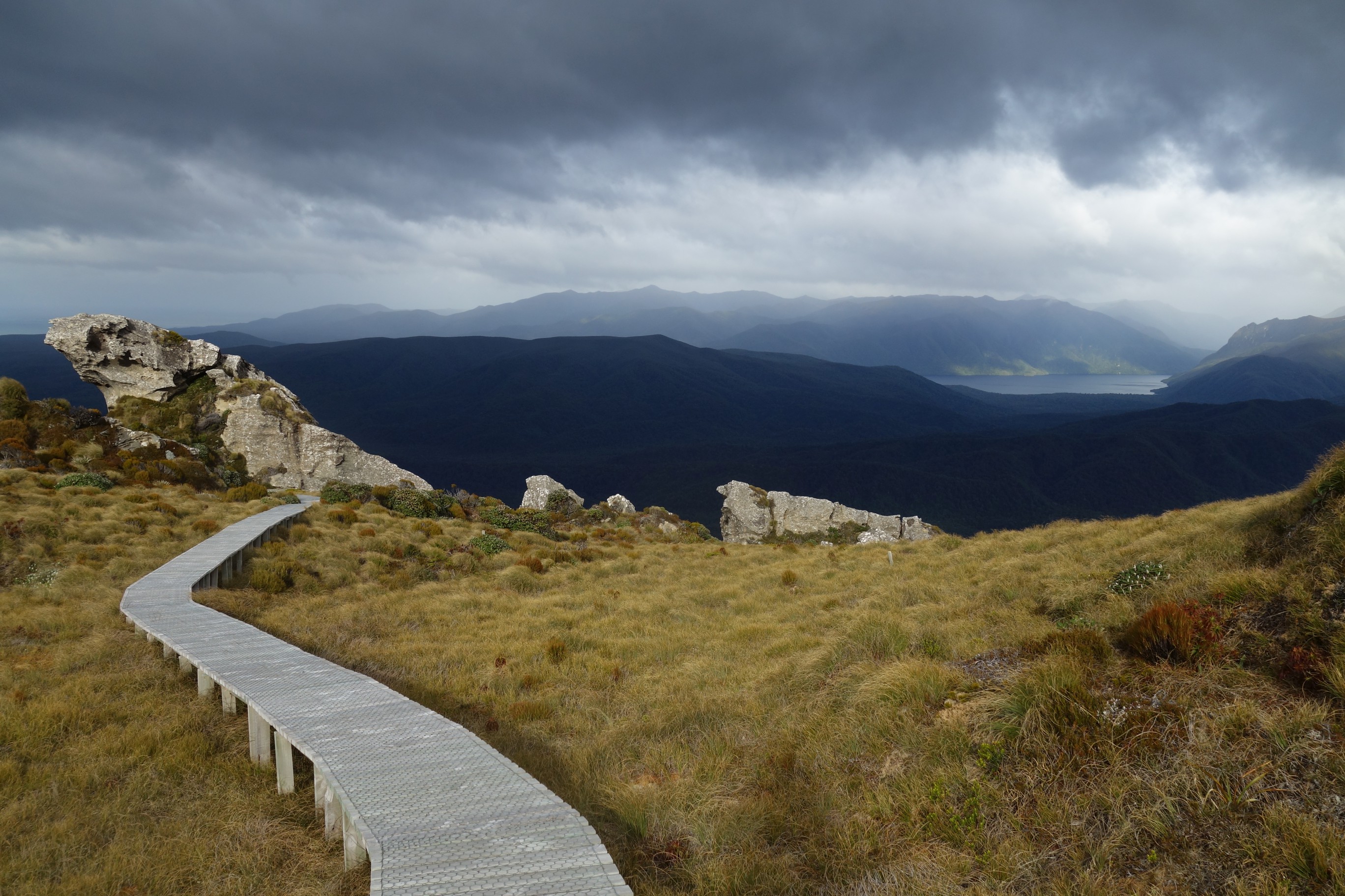
Thankfully things improved when I got to Fjordland National Park after Track Burn river, with some lovely forest, plus the longest stretch of boardwalk I’ve ever come across. Literally walked for half an hour before it stopped. Apparently 12km of the total track is boardwalk, great for avoiding mud and damaging the terrain, but a little easy / dull to walk along.


After three and half hours I finally reached the Water Bridge Shelter for some much needed lunch. Water was collected direct from the river via a bucket off the bridge!


A rest was wise as the next section is the toughest of the track, on a par with the ascents on the Kepler and Routeburn, but after 15km of walking already that day, going up more than 600m in 7.5km is a reasonable push. The forest was pretty gorgeous though.

It was all worth it after 5.5km when I reached Stag Point, with epic views, including a hazy Stewart Island in the distance.


Escaping the forest onto more boardwalk provided more expansive views.


After 19km and nearly six hours walking I arrived at Okaka Lodge, soon discovering why they had replaced the word hut with lodge on the signs.
It was the flashiest place I’ve ever stayed while tramping, with a gas fire, fully equipped kitchen, lights, mobile reception, sofas, inclusive porridge in the morning, and a fully stocked bar!

For those willing to pay more options include hot showers for $10, private rooms at the lodges, and for your bag to be helicoptered between lodges, truly glamping! I had a bunkroom designed for eight to myself anyway, as there were only five of us on the track the weekend before Christmas.
The best part though was the fully boardwalked loop track up above the hut which provided even more spectacular views, tarns (those mini alpine lakes), and probably the most unusual rock formations I’ve seen in New Zealand. I went up twice the day I arrived…


But glad I went up for a third time in the morning of day two, for some dramatic shots as the sunshine gave way to dark clouds.


Setting off from Okaka Lodge after large quantities of porridge the track then followed the ridge line, descending reasonably steeply down toward the coast, with a noticeable difference in the foliage and some more epic views.


The historic part of the track then starts, as you join the old tramline along which they transported logs to the ill fated Port Craig mill. This area was the home of the most ambitious milling project in New Zealand history, which only lasted twelve years, until 1928. There are a number of impressive viaducts remaining though, starting with the impressive Edwin Burn viaduct, a pleasure to walk across, high above the river bed below.

The tramline is pretty cool to walk along, but after a couple of hours it does get a little repetitive, being basically straight, flat and quite muddy.


The Percy Burn viaduct is possibly the largest surviving wooden viaduct in the world, 125m long and 35m high. You can’t walk over it but it’s still a hugely impressive sight in the middle of basically nowhere.


There’s one more viaduct on the track, Sand Hill viaduct, which is merely 59m high and 17m high.

Reaching Port Craig you’re greeted by the super cute DOC hut, an old school, dating from the days of it being a bustling little town servicing the mill.

Next door is the Port Craig Lodge, up to the standards of Okaka Lodge, but the best views are from the helipad.


Port Craig itself is a fascinating place, one of the most interesting historic sites I’ve visited in New Zealand (and I’ve visited most of them by now). With an informative leaflet and signage I had a great hour exploring what remains of the mill and town.

 The best part was down on Mussel Beach, where the saw mill was located, now home to the remains of the wharf, a couple of carriages used to haul rocks to build the breakwater, and the remains of an old crane. It’s also a lovely spot, and home to the rare Hector Dolphins, which as the world’s smallest (about 1.6m long) are not very easy to spot!


I got going early on day three, seeing the sun come up.

The first couple of hours weren’t particularly memorable but Blowholes Beach certainly was, with breaking waves, epic skies and a huge rainbow.


There was more average bush, that I’d already walked along on day one, before returning to Bluecliffs Beach, which looked even more stunning than on the first day.

In terms of difficulty the track itself is technically not challenging, but you will need to be fit enough for three consecutive 17-19km days. One way to lighten your pack is to buy food at the lodges, with the dehydrated meals pretty much the same price as you’d find them in the shops.
As the track is usually walked in one direction the only other people you’re likely to come across going the other way are on the little used South Coast Track which the Hump Ridge Track shares for half it’s length. In three days walking the weekend before Christmas I only came across three people on the track.
Tuatapere is the closest town to the track, 25 minutes drive away, and a pleasant place to spend a night. It’s an hour west of Invercargill and two and a half hours south of Queenstown (the route I took, flying down from Auckland), and home to some rather nice heritage buildings and a giant sausage!


Leave a Reply