The first three days on the Snowman Trek, one of the longest and hardest hikes in the Himalayas. Around 40% of all hikers in Bhutan walk this first section as it is shared with the six day Jhomolhari Circuit, eight day Jhomolhari Trek, 11 day Laya-Gasa Trek, and the 24-28 day Snowman. It climbs 1,300m in two days before a day of rest and acclimatisation at Jhomolhari Base Camp.
We drove from Paro (2,280m) to Shana Camp (2,790m), adjusting to the rhythm of the trek and sleeping in a tent for the next 28 days. After a cold evening it was sunny and warm in the morning, as the camp caught the morning sunshine.

We headed across a bridge strewn with colourful prayer flags, a frequent sight in this devoutly Buddhist country.

The terrain was very similar to hiking in the South Island of New Zealand, with trees covered in hanging moss, plenty of mud to navigate carefully, and a roaring river which the track followed, and frequently crossed.


A couple of hours in we took a short break at Shing Karap, a handful of buildings at 3,100m above sea level, home to a colourfully attired horse.


Beyond it is the path to the closed border with Tibet, though smugglers are known to use it at night. Cigarettes can be smoked in private in Bhutan but not sold, driving an active black market to bring them into the country.

I wondered why we weren’t using this bridge, before coming across this one a little further upstream.


Although Bhutan is far cleaner than many places I’ve been hiking I still managed to fill three bags with small rubbish today. I wish I’d brought some larger bags to tackle the many plastic bottles discarded by the track.


With no roads the main way of transporting everything is by horse. We came across a number of groups coming the other way, best keep your distance and stand against a rock face rather than by an edge when they pass.

After lunch the weather turned to moderate rain, encouraging some fast walking to reach our camp at Soi Thangthanka. Unfortunately we were a bit too fast and arrived well before our bags did, though thankfully the food and tents made it before us.


The next day continued with similar scenery, heading up a muddy but thankfully rocky track, surrounded by beautiful moss covered trees. The weather all day was atmospherically gloomy, with low cloud and frequent rain showers.


After about an hour we emerged out of the forest into a broad valley home to some very small villages and a number of stupas in various forms (including a mani wall and chorten), another water powered prayer wheel (a mani chukor), and a crematorium for the valley.


The power lines we followed for two days were installed five years ago, providing electricity to the six villages in the valley. It’s great that the Bhutanese government is bringing services (including mobile phone reception) to remote areas but the poles and lines do contrast with the surrounding landscape.


Jhomolhari Base Camp (4,080m) is oddly named as it wasn’t used by either party that climbed the 7,314m high Jhomolhari before mountaineering (climbing any mountains over 6,000m high) was banned in Bhutan to respect their sacred nature. It is apparently one of the busiest campsites in the whole of the Himalayas. It was relatively quiet though at the wet end of the monsoon season. We shared it with only a few other groups, including two groups who were at Soi Thangthanka with us, a group of four Americans also walking the Snowman, and three Catalonians walking the Jhomolhari Circuit. It didn’t feel crowded, with plenty of space for everyone.

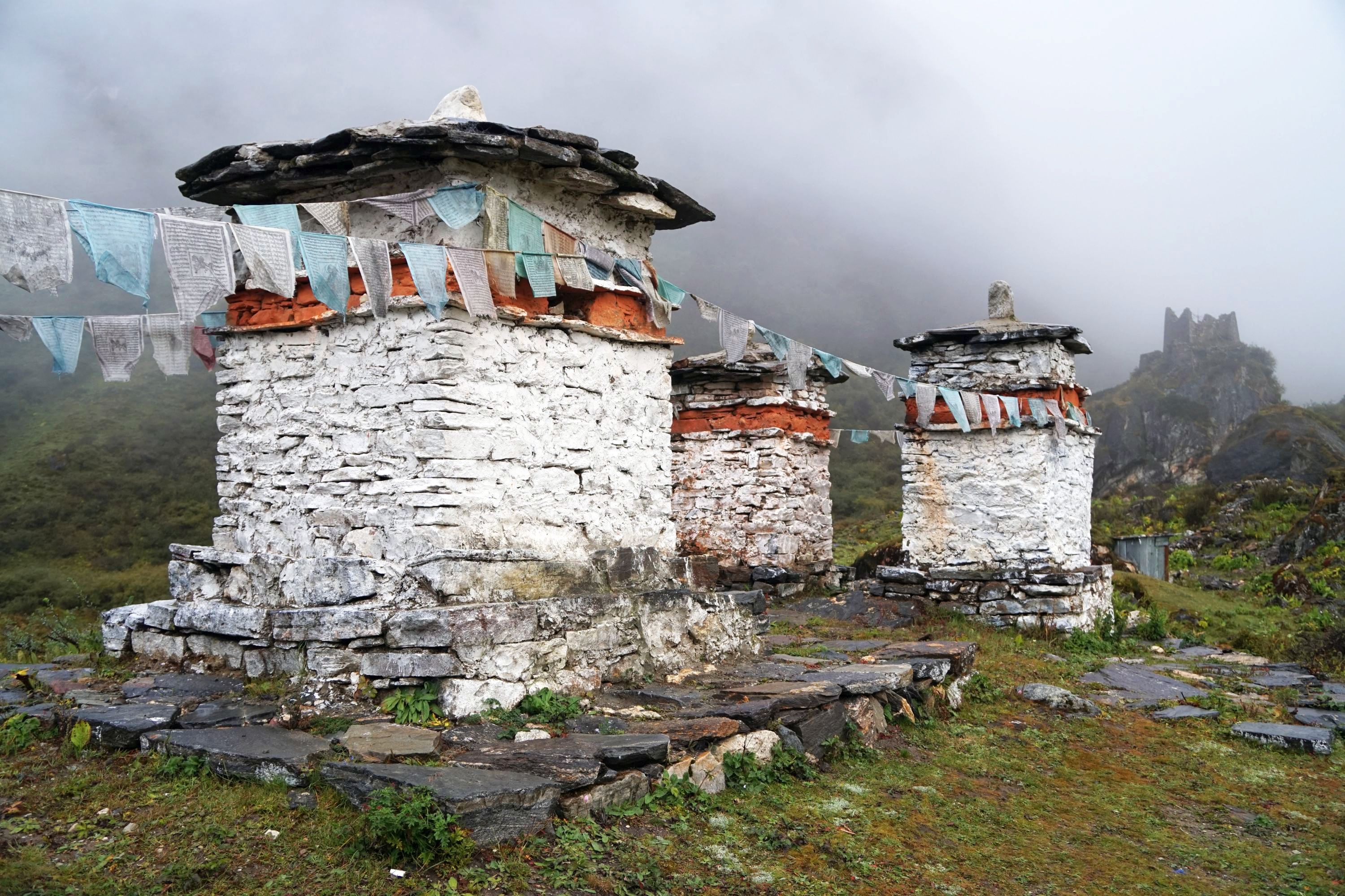
By the camp is a small but striking ruined fortress perched on a couple of small hills.


There is also a photogenic set of five chortens.


My perception of the weather went from it being atmospheric to a bit miserable with steady rain most of the afternoon, evening and overnight, when got down to about 4C. Everything was damp but it was still a pleasure to be in the mountains, even if wearing six layers of clothing.
After ascending 1,800m (walking 1,300m and driving 500m before starting the track) in a few days it is standard and recommended practice to spend a day at base camp acclimatising. Even by Soi Thangthanka a number of people in the group were starting to get symptoms of altitude sickness (loss of appetite, headaches, nausea). Thankfully I was ok, probably as I’d been taking Diamox since the trip started which alleviates altitude sickness to a degree. It does come with side effects though, including in the early days tingling in toes and fingers at times, and an increased need to use the toilet.
The best weather is apparently at sunrise between 5.30am and 6am, but not today. It was marginally clearer though, offering teasing reveals of the epic landscape behind the ever present cloud and rain.


On our acclimatisation day we went for walk north up an increasingly steep ridge to about 4,700m above sea level, similar height to the first of the high passes we would tackle the following next day. From here can be seen spectacular views of some of the highest and most beautiful mountains in Bhutan. Not today though thanks to the persistent rain which turned to snow at the top, though it was still a good workout before a quiet afternoon back at camp.


Leave a Reply