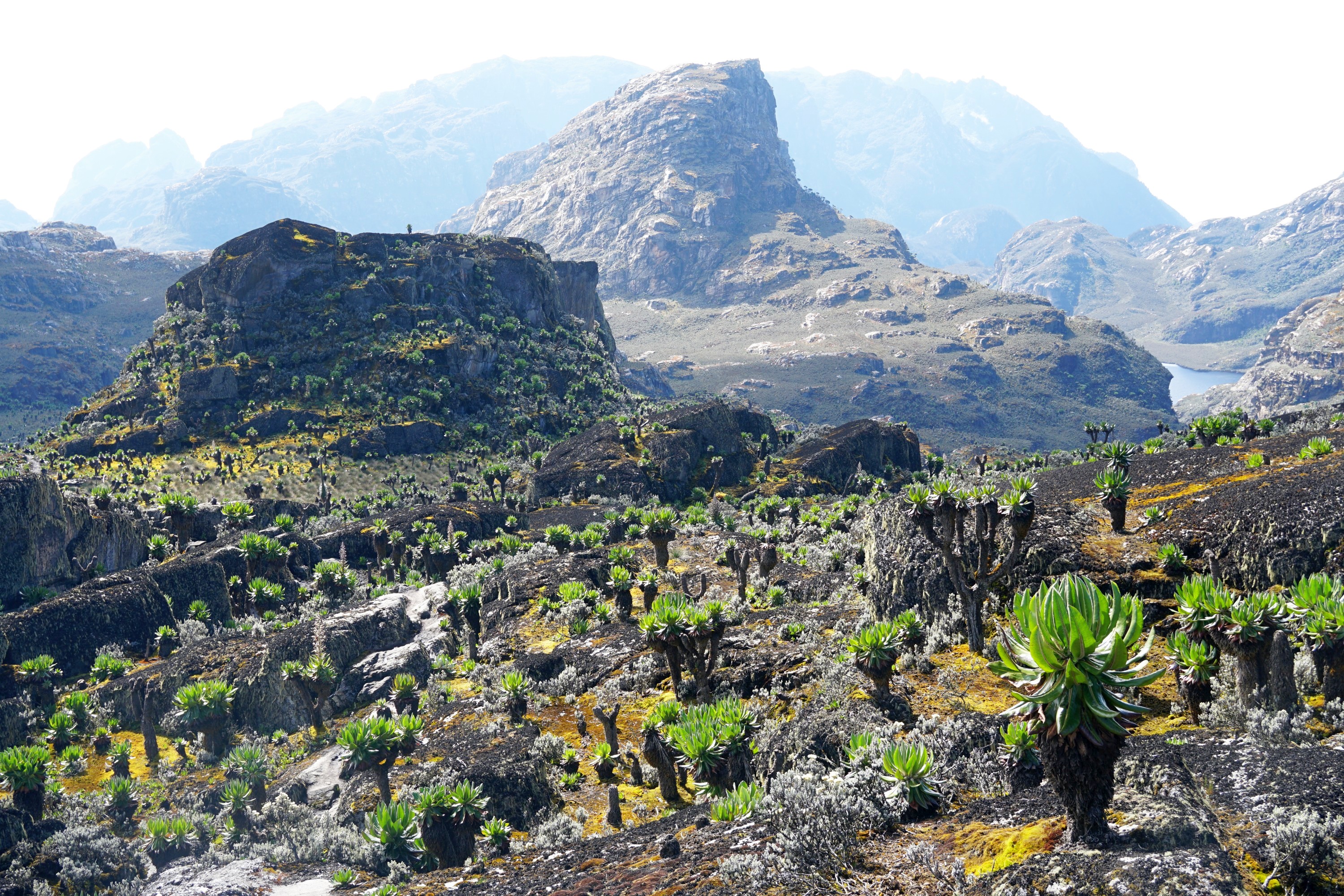
The Rwenzori Mountains are one of the best kept secrets in hiking, with less than 1,000 people a year exploring one of the most varied environments on the planet. A typical 7-10 day circuit hike takes in rainforest, bamboo forest, surreal sub-alpine and alpine zones, lakes, glaciers, and the third highest peak in Africa, Mt Stanley, at 5,109m. It isn’t easy though, expect mud that could swallow people alive, steep and slippery ascents and descents, highly changeable weather, and the challenge of walking at altitude.
The Rwenzori Mountains are a UNESCO World Heritage Site located on the border between Uganda and the Democratic Republic of the Congo. Most the hiking facilities and the majority of the range sit within Uganda. They are the highest mountain range in Africa, containing six of the ten highest peaks in Africa. Mt Kilimanjaro and Mt Kenya are higher but the usual routes are less technical than many of the peaks in the Rwenzori Mountains. Apparently the mountains are most popular with hikers from Germany and Australia, as well Americans and Russians.
Operators
The Rwenzori Mountains need to be walked with a guide and porters, provided by the duopoly of Rwenzori Trekking Services (RTS) and Rwenzori Mountain Services (RMS). They have completely different camps and routes. Both own their own camps, but RTS also own their own track. RMS is the original operator, locally owned, with their Central Circuit Trail in the middle of the park, mostly running along the bottom of valleys before heading up to the summits. They claim the shortest and easiest route to the summit of Mt Stanley, but it allows less time for acclimatisation, and the camps are definitely showing their age. They were built decades ago by the Ugandan Tourism Board, which looked the case when I walked past Elena Camp and Kitandara Camp.


RTS was established by an Australian in the 1990s, and operate a circuit out of Kyanjuki to the south. They have eight camps and are generally better reviewed online based on crew training, food quality, organisation, and the condition of the camps. I hiked with RTS organised through World Expeditions, for which I paid a margin but everything was organised from pick up to drop off at Entebbe airport, including all permits, accommodation and meals. There were only two of us on the ten day trip I did, which worked well as we had a guide each so could go at our own pace.

The standard RTS itinerary is eight days, which ends with a brutal three days, summiting Margarita Peak on day six, and then descending 3,500m in two and a half days, which took five to come up. It is generally downhill and the effects of altitude will lessen, but is still a punishing end, particularly after summiting Margarita Peak (which normally takes 10-12 hours) the itinerary includes a further 3-4 hour walk that day to Hunwick’s Camp. My ten day itinerary allowed a welcome rest after summing Margarita Peak, and four days to return to the start at a more enjoyable pace.
Facilities
The camps vary a little but follow a similar format, with several four or eight bunk huts, complete with mattresses, a dining area, a kitchen, and separate sleeping quarters for the guides (close to the clients) and porters (usually a little way away). There are decent squat toilets and less decent sit toilets (at some camps), and paper is provided. Your crew can provide hot water for washing, and some of the lower camps have streams or waterfalls just about warm enough to wash in. There are solar powered outside lights at most camps, handy when going outside to use the toilet in the night, less so for enjoying the stars. Some of the camps have solar lights inside the bunk rooms. From Bugata Camp onwards there are stoves though they seemed as likely to smoke you out as to provide significant heat. The camps work on a first come first serve basis in terms of room allocation but over nine nights there was only one night when we had to share a hut with someone else.


Food
You won’t go hungry. Breakfast was porridge followed by a cooked breakfast of omelette or pancakes. A packed lunch was provided with a sandwich or potato salad, fruit, and fruit juice. Mid afternoon tea, coffee and hot chocolates with biscuits was available. Dinner was mushroom soup followed by large cooked meal, usually pasta or rice with vegetables or meat, though no dessert.


Water
Water is taken from the camp streams and boiled to ensure it is safe to drink, though the crew often drink straight from the streams. The water is a somewhat unappealing colour at some camps thanks to tannins in the water, but is fine to drink. The only issue is that boiling water can take some time to cool, so there is a bit of planning required to ensure that your water bottles are cool when needed.

Crew
Everything has to be carried into the mountains, the track is too difficult for pack animals. A typical ratio is six porters per client, with each porter carrying 50 litre plastic drums weighing 22-25kg. As the hike continues, and there is less to carry, porters start to return back along the track. We had a guide each so could walk at our own pace, and a personal porter to carry up to 15kg while I carried a day pack of a similar weight, mainly due to the six litres of water I carried. Guides take up to five years to be trained, starting as general porters, then personal porters, then guides once they have sufficient training and experience. They’re amazingly nimble over the terrain and don’t appear to drink or eat anything while walking.


Weather
As with most mountain ranges the weather is highly variable! But it was generally fine from sunrise at 7am for a few hours, before starting to cloud over. Rain mid afternoon for between ten minutes to two hours was common, followed by a burst of sunshine just before sunset about 7pm.


Popularity
Less than 1,000 people a year walk in the Rwenzori Mountains, the vast majority of whom walk in the two dry seasons, lasting for about six months of the year. The numbers in the 2019/20 season were apparently lower than the previous year due to concerns about Ebola in the neighbouring Democratic Republic of Congo, though there was no risk in the Rwenzoris. For comparison Mt Kilimanjaro attracts ~50,000 people a year, and Mt Kenya ~25,000. In 2018 800 people reached the summit of Mt Everest, I suspect fewer than that summit Mt Stanley each year, and the season is much longer so you’re likely to have the mountain to yourself.
Difficulty
This was one of the harder hikes I’ve done, and I’ve completed some challenging ones including the Larapinta Trail, Kokoda Track and Snowman Trek. The main challenges were the…
- Terrain, with extensive sections of bog with thick and often deep and liquid mud to navigate, many steep sections on slippery rocks and mud, and basic wooden ladders to climb up and down. I’d estimate that around a third of the track was thick mud, at least 20km worth
- Altitude, from the entry village of Kyanjuki near Kilembe at 1,620m above sea level you head up ~2,100m in two days, and can end up 5-6 days into the hike at Margherita Peak, the 5,109m high summit of Mt Stanley. I’ve been at higher elevations in the Himalayas but the track here was far steeper in places, and there was less time for acclimatisation
- Weather, the early sections were hot and humid, but after Mutinda Camp it starts to get alpine and significantly colder, while the weather can be variable throughout, with rain likely at some point most days, usually mid afternoon
- Entry level mountaineering, required to reach the summit of Margherita Peak, with crampons, an ice axe, and harness, and basic instruction provided by the crew before heading toward the summit to ascend, traverse, and descent fixed and temporary ropes, and cross two glaciers
- Concentration required, I’ve rarely had to focus for as long as walking into the Rwenzori Mountains, to deal with the various challenges mentioned above, this isn’t somewhere you can take photos while walking
Given these challenges I felt as tired after walking for four hours as after eight hours in New Zealand. This is one track that is much harder in reality than it looks on paper, which appeared to catch out many people I met on the track, with comments overheard such as “I didn’t believe that there could be so much mud!” and “kill me now!”. One group of eleven ended up split across four different camps as various members couldn’t make it any further…


Other things to note
- There was almost no litter along the track, it was as good if not better than tracks in New Zealand, which was wonderful to see.
- Gumboots (aka Wellington or rubber boots) are essential. I was sceptical at first, in New Zealand hiking boots and gaiters are usually fine for dealing with mud, but speaking to a friend who has walked in the Rwenzori Mountains twice and reading online convinced me. I have never come across so much mud, spending literally hours walking through bogs that you could disappear into up to your waist if not careful. Hiking boots are fine for the first couple of days, and for summiting the peaks, but would get soaked in the bogs. I wore my gumboots six out of the ten days spent hiking in the Rwenzori Mountains. A couple of tips I heard on the track were to duct tape the top of your gumboots to your trousers or to wrap your gaiters around your knees in case your leg does disappear. If you’re careful though these shouldn’t be needed, though there is a bit of an art to working out from appearance the depth and consistency of mud…


Leave a Reply