Taking advantage of rare (mostly) good weather in the Tararua Ranges (where cloud or rain prevail 80% of the time), I hiked a tough three day 66km circuit with over 5,000m of ascent and descent, starting and finishing at Kaitoke, only 45 minutes drive from Wellington. The original plan for my first multi-day tramp after moving to Wellington was the famous Southern Crossing, until the logistics of this one way three day tramp deterred me. Instead looking at the map I decided on a route which covered two thirds of the Southern Crossing before returning to where I parked my car, staying at Alpha Hut and Maungahuka Hut.
From the car park at Kaitoke the Dobson Loop Track headed uphill, in keeping with most of the day. It was pretty slippery, with wet clay and mud, but offered the occasional view behind of the landscape.


I soon reached the Marchant Ridge Track, along which I spent most of the day, walking through endless beech forest.


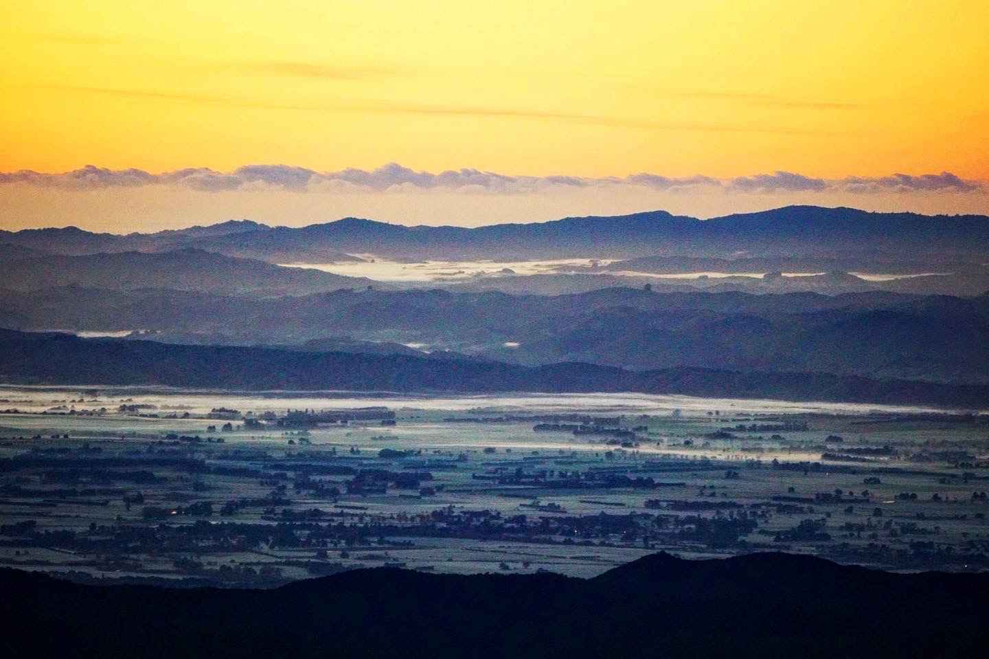
Two and half hours after I left the car park the track opened up for some spectacular views, both to the south with Wellington in the distance, behind which across the Cook Strait were the snow covered Kaikoura Ranges, and to the east the lush green plains of the Wairarapa.


It was quite an eerie landscape with dead trees rising out of the bush, and beech clad hills all around.


Most of the rest of the day was spent in a goblin forest environment of lichen covered trees along the top of the ridge. Very atmospheric if devoid of the sound of any wildlife. The only people I saw all day were a couple walking out after spending the night at Alpha Hut, and once the wind dropped in the afternoon it was completely silent.


Just before Hells Gate I again emerged out of the bush to stunning views in every direction.

Heading up Dress Circle Track was quite a slog due to some confusing track signage. At the car park it’d said 5-7 hours to Alpha Hut, whereas my previous research suggested 7-9 hours. Optimistically thinking I could cover the 15-20km (again depending on the source) to Alpha Hut in five hours I didn’t stop for lunch. By the time I realised that it was going to take longer to reach the hut I couldn’t bring myself to stop, and pushed on, walking seven hours without a break to reach Alpha Hut by 3pm. The hut was a very welcome sight. In retrospect the quicker timings must have been for walking along by Smith’s Creek, which was much easier than the Marchant Ridge Track.


While waiting for my very late dehydrated lunch to hydrate I popped up behind the hut for some wonderful views of the landscape, just before the sun disappeared behind me. I walked the track in mid June so daylight was limited.


Before it disappeared entirely I revisited the spot for sunset light, before returning to Alpha Hut, which I had to myself. As usual it was a mixed experience, great when light, spooky and cold after darkness fell…

The next day was mostly wonderful, other than the last two hours, which were possibly the most terrifying of my life…
It started well leaving Alpha Hut at dawn, with a red glow lighting up the horizon.

A cute Morepork (native owl) was sat on a DOC sign, I’d heard it’s distinctive “more-pork” call earlier on.

The views of the Wairarapa as the sun rose were quite stunning, with the views improving as I headed higher.


This deer was a less flighty than they usually are.

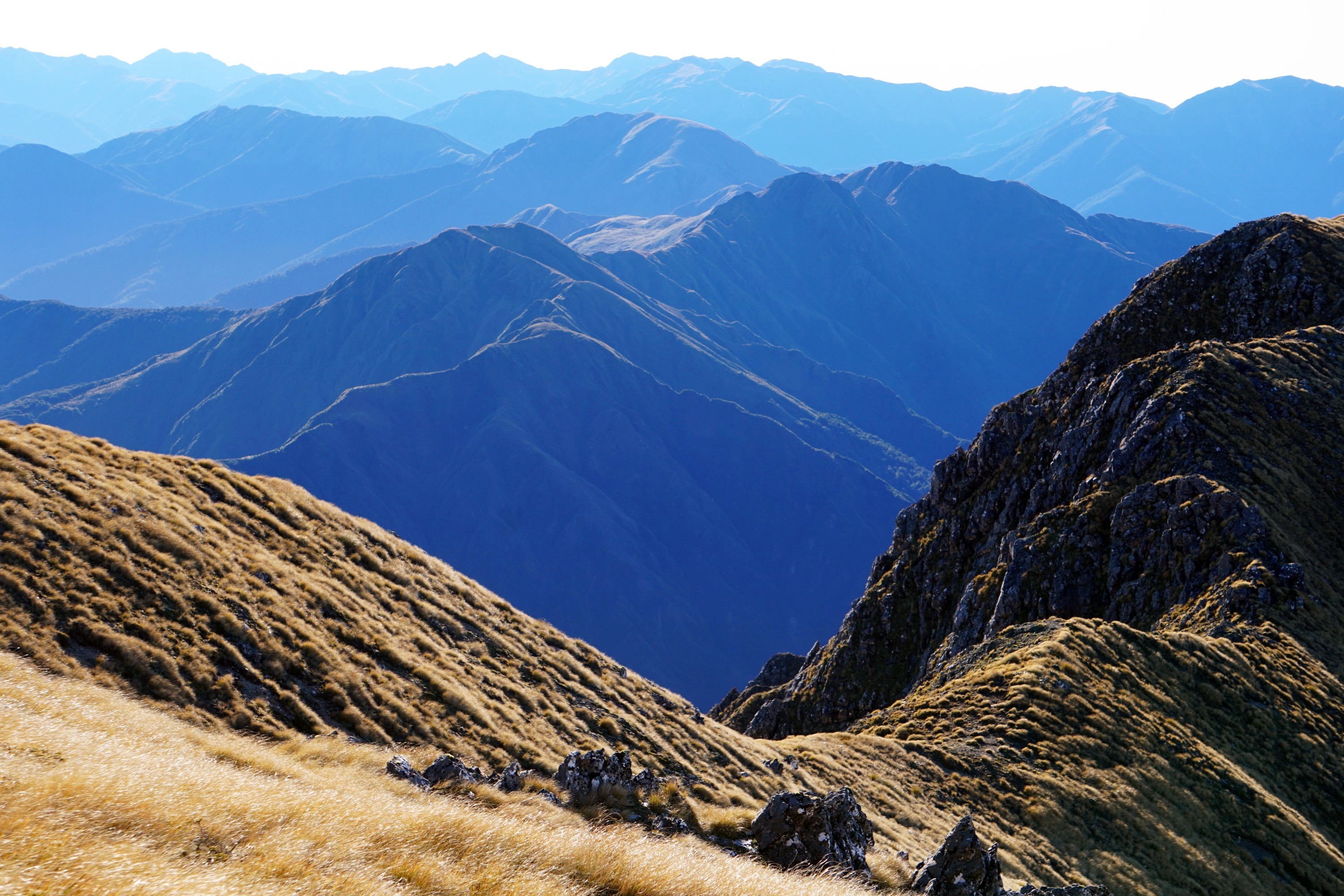
I spent the whole day on the tops, constantly up and down often narrow ridge lines. The views were quite epic though, and the weather perfect, with not a cloud in the sky and unusually light winds for the Tararuas, perhaps only 30kph.


At 1,529m above sea level, Mt Hector is one of the highest point in the Tararuas. At the summit a large cross was carried up and erected in 1950 to commemorate trampers that died in WW2.


On the descent Kapiti Island was visible in the distance, before reaching Kime Hut at a much more sensible time for lunch compared to yesterday.


It is a beautifully located hut, though without any heating it is notoriously cold at times.


I didn’t linger long though as I was only half way to my destination for the day. Heading on the views continued to amaze, though it got increasingly muddy and slippery underfoot.


Around half two in the afternoon clouds started to form in the distance.


They rapidly made their way toward me, which didn’t seem too much of a problem at the time, and provided this unusual photo opportunity with my shadow being cast on the clouds below, surrounded by a rainbow, technically known as a glory.


However an hour later it was far less pleasant, with little visibility and the wind picking up. I was only 2km away from the Maungahuka Hut, but the sign said it would take 1.5 hours, the going would get tougher. I knew there was a ladder to descend and the contour lines on the map were very close together but I hadn’t appreciated quite how difficult and scary the next couple of hours were going to be.


The path got increasingly narrow, and the drop offs increasingly steep, before I reached a section where I literally had to rock climb to progress. I put my camera and poles away to free my hands, and I moved my Personal Locator Beacon (PLB) from it’s usual home at the top of my pack to the pocket of the waterproof jacket I was wearing. Falls are the number one cause of death for hikers in New Zealand (followed by drowning), and I’m uncomfortable with scrambling at the best of times, let alone when enveloped in thick cloud and increasingly strong winds. The Tararuas have a reputation for extremely changeable and extreme weather, as I found out in the worst possible place.

I could just about make out the marker poles, but they often seemed in almost impossible to reach places. I had to scramble on all fours up rock faces (not that easy carrying a 18kg pack), and worse was coming down equally steep sections, which I did often on my backside, grasping onto whatever rocks or plants I could find to steady my descent.

I then came across chains, which made it easier in some ways, but there is a reason for their presence, i.e. steep drops below and very narrow ledges. I’ve used chains in the Alps but they weren’t like this…

A long stretch of chains took me to the top of the ladder I’d seen on the map. Though more secure and reassuring than the chains, the 25m high ladder felt endless. I looked down once and regretted it as all I could see was cloud below into which the ladder disappeared. My hands were absolute frozen from the cold metal and my breathing (as for most of this experience) was on overdrive.

It was a relief to finally reach the bottom, to a slightly wider area in which I could take a break. I put warm layers on underneath my jacket, as I was getting a bit concerned about hypothermia given the damp and windy conditions. I had some water and food, and try to warm my hands. I couldn’t rest for long though as it was noticeably getting dark (downside of hiking in mid June).
I thought the worst was over with but that illusion was shattered a few more metres along the track when chains appeared again.


I was warm, relatively dry, had a decent torch, and more energy than expected after ten hours of tough hiking, but the whole experience was quite terrifying. These photos hopefully give an idea of the conditions, with more scrambling up and down steep rock sides, but the worst is not pictured as self-preservation was more important than photos. I was quite tempted to stop and use my PLB but being rescued from here wasn’t going to be an option today, and the thought of a night out here seemed impossible. I could tell from the maps that I was getting increasingly close to the hut, but it was slow going.
I was so relieved when a white toilet appeared through the gloom and I finally made it to Maungahuka Hut before 6pm. The whole experience was enough at the time to put me off hiking, or at least in the Tararuas. Afterwards I came across this blog, describing a similar experience though in the rain. I could relate to their comment “In my 30 years of tramping, traversing all sorts of terrain and scaling various mountains (including Mt Kilimanjaro where deaths also happen frequently), this was by far the most gnarly and nerve-racking hike I have ever done”.

Overnight the wind picked up even more and the hut remained enveloped in cloud, which didn’t make for great sleep as I wondered whether the track ahead would be as terrifying as from where I’d just come. The map gave me some relief as I’d walked along a ‘route’, whereas tomorrow was along a ‘track’.


I had a long day ahead but decided to wait until it was light before heading out given the conditions. It was incredibly windy and cloudy, but thankfully dry and the track was generally wider, and only one section requiring scrambling. I’ve rarely been quite as relieved to get into the bush and away from the wind.


From here it was a tiring couple of hours descending ~1,300m to reach Neill Forks Hut, a classic 6 bunk back country hut maintained by the NZ Deerstalkers’ Association.


I didn’t stay long though I as had a lot of distance still to cover, starting with a near 1,000m trip up to Cone, down to Cone Saddle, and onto Cone Hut. On the climb up to Cone Ridge there was a fair amount of windfall, slowing progress.


The ridge though was great, with relatively the flattest and fastest section of track of the trip to date, through wonderful lichen covered forest.


I emerged out of the bush at Cone to an interesting bog / tussock landscape framed with a rainbow. I wasn’t able to appreciate it fully though as I had to focus on not getting blown over. I was greeted with possibly the strongest winds I’ve ever come across, requiring a crouched crab like stance, and full use of both poles, to make my way to the safety of the bush. My pack rain cover was caught by the wind and turned into a parachute pulling me back…


From here was another long descent, passing by some huge old trees before reaching Cone Hut.

The second oldest hut in the Tararuas, built by the Tararua Tramping Club (the oldest tramping club in NZ) in 1945, it was nearly removed in the 1980s but was thankfully restored and seemed a very pleasant place, other than tadpoles in the water tank!


It was 2.30pm by then, with another late and short lunch, before heading along mostly flat track along by the Tauherenikau River.

At about 4pm, just before Tutuwai Hut I met the third person of the entire trip, a hunter with an enthusiast dog, which thankfully was on a leash. My original plan had been to spend the night there, tackling the final 14km back to my car at Kaitoke in the morning. In my haste though I managed to miss the turnoff to the hut, only realising 15 minutes later. After seven hours of tough hiking I was unexpectedly still feeling fairly fresh, was conscious of the forecast of rain for the following morning, and keen just to get home, so I decided to push on.
I definitely felt less fresh though by 8.30pm when I finally reached my car after three hours walking in the dark. I had a decent head torch, was warm and dry, and quite enjoyed the experience other than occasionally losing the track, scanning around for the orange track markers (which unfortunately are not reflective…) and resorting to the GPS app on my phone at times.


Overall it was quite an experience. Although I wasn’t limping at the end (as I was after my last hike in Nelson Lakes National Park) I don’t think my boots have ever been as muddy, my ankles, hips and collar bones were red raw, and my legs, hands and arms covered in small cuts. The views and scenery had been sublime at times, but the Tararua Peaks section after the weather turned was absolutely terrifying. Nearly getting blown over the following day wasn’t ideal either… I survived though, and had all the right equipment so I was never cold, hungry, or particularly lost, and had a PLB if things had turned out for the worse.
I learnt that the DOC timings for the Tararuas are ridiculously optimistic. I’m normally 20-30% faster than their times but struggled to meet them here. The Tararuas dangerous reputation is well deserved and needs to be respected. Since 1990 twenty two people have lost their lives here. I’m looking forward to exploring them further but only when the weather forecast is near perfect, and even then with care, prepared for the worst.


Leave a Reply